The Trump administration's move to limit export of AI-based geospatial imaging software extends U.S. restrictions on technology that foreign countries could use to develop weapons systems.
The U.S. government moved to restrict geospatial AI imaging software to try to prevent foreign countries from using the technology to develop advanced weapons or spying systems.
The Commerce Department issued an interim rule that took effect Jan. 6 requiring vendors of geospatial AI software to apply for a license before selling it in foreign countries other than Canada. The measure appears primarily aimed at China.
Geospatial AI growing
The measure, open for public comment until March 6, affects the burgeoning geospatial AI industry, which has been advancing the technology rapidly in recent years and selling it into the transportation and agriculture sectors, among others.
"This rule is being issued in interim final form because while the government believes that it is in the national security interests of the United States to immediately implement these controls, it also wants to provide the interested public with an opportunity to comment on the control of new items," according to the rulemaking notice published Jan. 3 in the Federal Register.
Nonmilitary uses
Los Angeles-based Slingshot Aerospace, a 2016 startup, sells AI and analytics-based software to perform analysis on satellite, aerial and drone signals.
The company, which has a $6 million contract with the U.S. Air Force, as well as with various commercial and military aerospace companies, has trained deep learning networks to automatically detect water, water silos, debris and other objects of interest in geospatial imagery for dealing with natural disasters.
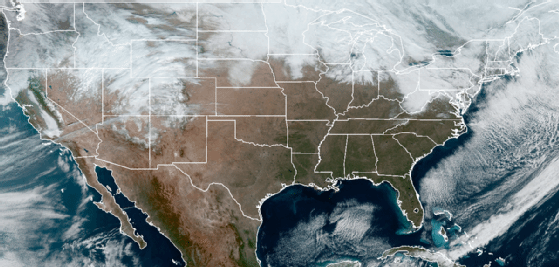
Satellite image of continental United States
Their software "can process entire countries' worth of imagery," David Godwin, CEO and co-founder of Slingshot, said in a recent interview.
In addition to automatically identifying resources, structures and landmarks in geospatial imagery, the company can also use Geospatial analysis and deep learning to predict where objects are in space at any given point in time, Godwin said. Customers use the vendor's technology to help prevent collisions in space, he continued, noting that NASA is a client.
Geospatial imaging has been a sensitive area for a long time.
Steve ConwaySenior vice president of research, Hyperion Research
A spokeswoman for Slingshot said no one from the company was immediately available to comment on the federal rule.
The measure does not affect other AI technologies or classes of software, and it simply extends longstanding U.S. restrictions on similar technology, said Steve Conway, senior vice president of research at Hyperion Research in St. Paul, Minnesota.
A traditionally sensitive issue
"Geospatial imaging has been a sensitive area for a long time, but now it's getting to be much higher resolution so you can really zoom in," Conway said, noting that the Google Earth mapping application came under criticism by many countries more than a decade ago.
"There's a pretty big sector that makes this and many commercial uses for it, but I very much doubt this will be a surprise," he added.
The rule specifically focuses on software that automates the analysis of geospatial imagery. Many geospatial AI imaging tools are used to train the deep learning-based neural networks to automate the analysis of geospatial imagery.